Log in
All resources
Create a design
Tools
1,787 Free Images of French Language Maps
bibliothèque nationale de france
maps from gallica
guides joanne
maps by willem and johannes blaeu
lucas janszoon waghenaer
robert cordier (engraver)
guillaume sanson
sanson maps of the circles of germany
maps by nicolas sanson
john rocque
carte des environs de paris (1678)
bibliothèque nationale de france
carte des environs de paris (1678)
bibliothèque nationale de france
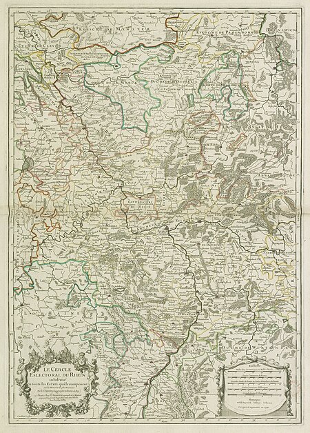
map of the circle of the rhineland by sanson
1730s maps of rhineland-palatinate
nouvelle géographie universelle
1887 maps of africa
le royaume de france distingué by guillaume sanson
1724 maps of france
1667 map of madagascar by guillaume sanson
bibliothèque nationale de france
le royaume de france distingué by guillaume sanson
1724 maps of france
maps of île-de-france by françois de la guillotière
atlas minor gerardi mercatoris (1614, maps)
map of the circle of upper saxony by sanson
bibliothèque nationale de france
maps of emden by braun & hogenberg
bibliothèque nationale de france
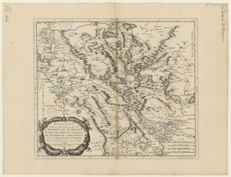
1660s maps of rhineland-palatinate
maps of vangiones by sanson
jean-baptiste-henri delahaye
philippe buache
vigo in the 18th century
1702 maps of spain
old maps of le tréport
maps from gallica
maps from gallica
guides joanne
map of modern syria by philippe de la rué
1650s maps of palestine
maps of grenoble by braun & hogenberg
maps of romans by braun & hogenberg
maps of groningen by braun & hogenberg
bibliothèque nationale de france
19th-century maps of south america
ambroise tardieu
map of the circle of bavaria by sanson
bibliothèque nationale de france
maps of italy by sanson and cordier
bibliothèque nationale de france
sanson maps of the circles of germany
bibliothèque nationale de france
maps of the course of the rhine by guillaume sanson
maps by nicolas sanson
maps of county armagh
1760s maps of ireland
17th-century maps of nord (department)
maps of artois
16th-century maps of the western mediterranean
lucas janszoon waghenaer
maps of brielle by braun & hogenberg
brielle in the 16th century
maps of amsterdam by braun & hogenberg
bibliothèque nationale de france
maps of london by braun & hogenberg
bibliothèque nationale de france
maps of nevers by braun & hogenberg
maps of autun by braun & hogenberg
maps from gallica
guides joanne
map of europe by guillaume sanson (1674)
bibliothèque nationale de france
sanson maps of the circles of germany
bibliothèque nationale de france
1746 books about geography
1746 books from paris
old maps of plymouth and devonport
16th-century maps of england
maps of lisbon by braun & hogenberg (1572)
maps of cascais by braun & hogenberg
maps with azimuthal equidistant projection
french-language maps of antarctica
maps from gallica
guides joanne
19th-century maps of the malay archipelago
19th-century maps of southeast asia
cartouche (cartography)
jean-claude dezauche
1660s maps of france
maps of lyonnais
carte des pays-bas catholiques by guillaume sanson
robert cordier (engraver)
maps of île-de-france by françois de la guillotière
bibliothèque nationale de france
maps of lyon by braun & hogenberg
bibliothèque nationale de france
1750s maps of north america
solomon bolton
maps by willem and johannes blaeu
17th-century maps of xaintonge
john russell (painter)
old maps of the moon
john russell (painter)
old maps of the moon
chambre des députés (july monarchy)
maps from gallica
chambre des députés (july monarchy)
maps from gallica
mappe-monde geo-hydrographique (sanson and jaillot, 1674)
bibliothèque nationale de france
maps of alsace by guillaume sanson
bibliothèque nationale de france
18th-century maps of istanbul
maps from gallica
maps by pieter mortier
maps from gallica
carte des pays-bas catholiques by guillaume sanson
robert cordier (engraver)
carte du mexique et de la floride by guillaume delisle (1703)
bibliothèque nationale de france
carte de l'isle de ceylan by guillaume delisle (1722)
bibliothèque nationale de france
l'empire d'allemagne divisé en ses dix cercles, et ces cercles en leurs principaux estats, principautés et souverainetés ecclésiastiques, laiques et villes impériales avecq le royaume de boheme et les... - btv1b53202355w
sanson maps of the circles of germany
considérations géographiques et physiques sur les nouvelles découvertes au nord de la grande mer
hokkaido in art
map of italy by guillaume delisle (1700)
bibliothèque nationale de france
1680s maps of rhineland-palatinate
maps of vangiones by sanson
old maps of nagasaki
guillaume dheulland
sanson maps of the netherlands
alexis-hubert jaillot
bibliothèque nationale de france
guillaume sanson
maps of alsace by guillaume sanson
bibliothèque nationale de france
cartouches by alexis-hubert jaillot
cartouches by sanson family
1700s maps of the netherlands
maps by nicolas sanson
john rocque's 1748 map of london and adjacent country
remigius parr
maps of the course of the rhine by guillaume sanson
maps by nicolas sanson
sanson maps of the holy land
old maps of canaan
lucas janszoon waghenaer
maps facing east
bibliothèque nationale de france
maps by thomas kitchin
pierre alexander tardieu
delaval (surname)
maps of schwäbisch hall by braun & hogenberg
bibliothèque nationale de france
françois de la pointe
1620s maps of france
lucas janszoon waghenaer
1580s maps of spain
amérique méridionale (1748, d'anville)
rococo
maps of halberstadt by braun & hogenberg
maps of quedlinburg by braun & hogenberg
maps of haarlem by braun & hogenberg
bibliothèque nationale de france
maps of formia by braun & hogenberg
bibliothèque nationale de france
maps by willem and johannes blaeu
17th-century maps of dombes
maps of st. gallen by braun & hogenberg
maps of konstanz by braun & hogenberg
18th-century maps of madagascar
pierre mortier
18th-century maps of madagascar
pierre mortier
bibliothèque nationale de france
guillaume sanson
l'espagne divisée by guillaume sanson
1670s maps of the iberian peninsula
carte du mexique et de la floride by guillaume delisle (1703)
bibliothèque nationale de france
cartouche (cartography)
maps by john rocque
maps of paris from the david rumsey historical map collection
maps of paris by caspar merian
considérations géographiques et physiques sur les nouvelles découvertes au nord de la grande mer
isla de los estados
robert cordier (engraver)
1789 maps of france
le comté de la marck, les seigneuries des abbayes de werden, d'essen et la ville impériale de dortmundt - dressé sur les mémoires les plus récents par le sieur sanson... - btv1b532024306
guillaume sanson
robert cordier (engraver)
1789 maps of france
old maps of europe
achille belloguet
bibliothèque nationale de france
félix robaut
old maps of europe
achille belloguet
maps of blâmont by braun & hogenberg
bibliothèque nationale de france
bibliothèque nationale de france
1667 sanson map of africa
jean-fréderic phélypeaux
guillaume dheulland
old maps of norway
guillaume sanson
1001 - 1100 of 1,787
Next page
/ 18


![Map of Perche / [Sanson et alia], 1676](https://cdn.creazilla.com/illustrations/10001032615/map-of-perche-sanson-et-alia-1676-sm.webp)


